Wyoming is home to some postcard-worthy scenery and wildlife, and the perfect sample of it is sprawled across Grand Teton and Yellowstone National Parks. While Yellowstone is home to the world’s largest hydrothermal features, Grand Teton flaunts the beauty of geological forces combined with crystal clear lakes formed by alpine glaciers.
This post is your complete adventure guide to Grand Teton and Yellowstone from where to find free campsites, epic hikes, shower and laundry facilities, park highlights and other services.

I spent around 3 weeks exploring both Grand Teton and Yellowstone National parks and found endless beauty and wildlife embedded in both landscapes. I would recommend at least a week to sufficiently get a feel for both parks, but I personally could have spent a month wandering around this region and still felt like I didn’t see everything.
Note for people traveling with dogs: There are no real dog-friendly trails in these parks, but there are some nice national forest trails on the outskirts of both parks. I recommend downloading the AllTrails app and searching for dog-friendly trails nearby to make sure your dogs enjoy the trip too.

All the suggested campsites, hikes, and park highlights are based on my personal experience. I have starred** all of my favorite activities and places.
But before we go any further, I’d like to acknowledge that Yellowstone National Park is on stolen land from Apsaalooké (Crow), Cheyenne, Eastern and Northern Shoshone, Bannock, Tukudeka, and Blackfeet tribes. Grand Teton National Park is on land stolen from the Shoshone-Bannock, Eastern Shoshone, and Cheyenne tribes.
Grand Teton National Park

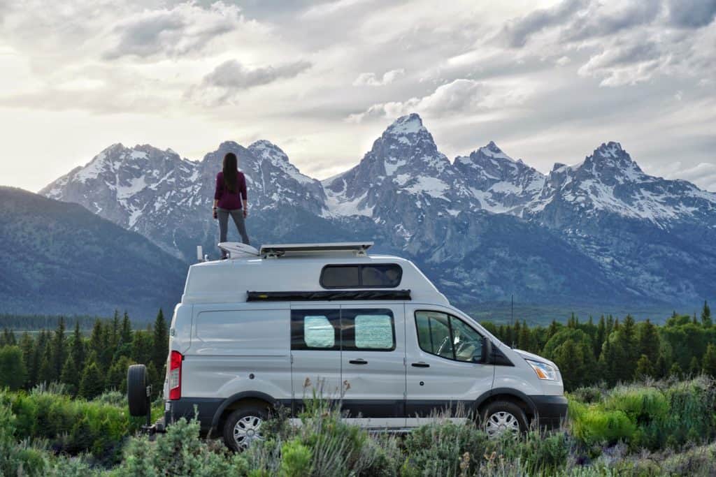
The jagged peaks of the Teton Range, combined with the forests, sagebrush flats, meadows, lakes and rivers make for an unforgettable experience in the Grand Teton National Park. Bears, bison, moose, elk, Pronghorn, beavers, otters, pikas, hawks, and bald eagles also call the 310,000-acre park home.
This magnificent skyline was formed by the Teton fault which precipitated earthquakes that lifted the mountain range and sunk the valley floor. Then glaciers, wind, rain, and ice sculpted the breathtaking landscape we see today.
Grand Teton is a much smaller park than its northern neighbor (Yellowstone), which makes it a little bit more accessible with a shorter amount of drive time to explore its marvels.
Download the free Grand Teton National Park Map (provided by the National Park Service) or purchase your own Grand Teton and Yellowstone National Park topographic waterproof map bundle. Please note that there are winter closures in the park, and you should go to a visitor center for the most up to date information.
Where to Sleep
The following are FREE camping spots near Grand Teton that I camped in during my visit to the park.

Shadow Mountain Area Camping in the Bridger-Teton National Forest (West of Grand Teton National Park)**
GPS Coordinates: 43.76371, -110.55641 (beginning of forest service camp spots)
- There are plenty of camp spots on/near Antelope Flats Road between the Moose and Moran park entrances on the West side of the park
- Designated but primitive forest service campsites with fire rings and nothing else
- First-come, first-serve, 5-day limit from May 1st- Labor day
- Amazing views of the Grand Teton Mountain Range at some of the sites along this road
- Decent Verizon coverage throughout the area (2 bars)
- Further you go up some of the roads in this area, the rougher it gets, but I made it fine in my 2WD Ford Transit
- Please note: a forest ranger really does come around daily to check that people are abiding by the stay limit and are in designated campsites
In addition to the Shadow Mountain Area where I camped, there are multiple sites for free undeveloped forest camping in the Bridger-Teton National Forest, including: Pacific Creek, Spread Creek/Toppings, Gros Ventre, Curtis Canyon, and Flat Creek. Visitor kiosks in the area can provide maps, or you can find these spots on Google Maps.
Nearby Services:
I highly recommend Dornan’s Pizza and Pasta Co and the deli located near Moose Junction. The rooftop dining area of the pizzeria has incredible sunset views of the Tetons and delicious gluten-free options. Moose Junction is a 20-minute drive from the campsites mentioned above. They also have a grocery store and surprisingly cheap gas.

Grassy Lake Road Camping in John D. Rockefeller Memorial Parkway (North of Grand Teton National Park)
- 8 camp areas including 20 dispersed camp spots on Grassy Lake Road (first-come, first-served)
- Located between the north end of Grand Teton National Park and the South Entrance of Yellowstone National Park
- Road is closed until June 1st for grizzly bear migration. Caution is recommended on this dirt road, but my 2WD van did fine under good weather conditions
- No cell coverage at any of these spots, but you can access very bad WiFi from the lodge/restaurant at the nearby Flagg Ranch Information Station
- These spots all include vault toilets and bear boxes, but do not have potable water
- The forest in this area has been burnt, and follows the snake river, offering some unique views
Nearby Services:
There is a small grocery store, gas station, and restaurant at the Flagg Ranch Information Center.
You can find other free campsites around the parks using the free iOverlander app.
Laundry and Shower Facilities
Coin-operated laundry and pre-paid showers are available at the following locations:
- Headwaters Campground and RV Park
- Colter Bay Village (May 23-Sept 29)
- Signal Mountain Lodge ($6 showers)
Hiking

I highly recommend talking to a park ranger before going on any hikes in the park to check trail and weather conditions and ask about wildlife sightings. I also recommend downloading the appropriate maps for the trails you plan on hiking via the AllTrails app or grab a trail map from the park visitor centers. The following three trails are hikes I did that I found beautiful and worthwhile.
Please make sure you always carry bear spray when hiking in bear country!
If you plan to do any wilderness backpacking, check out my Backpacking Pack List & Guide.

- Death Canyon Trail (Strenuous)**
- 7.9 miles roundtrip, 6 hours, 2100 ft total climb
- Begins at Death Canyon trailhead, climbs to an overlook with views of Phelps Lake, then drops towards the lake, and climbs the canyon to a patrol cabin where the turnaround point is. If you hike about a mile past the cabin though, you’ll probably catch a glimpse of moose drinking in the meadow and some beautiful views of the Tetons. I also spotted a family of black bears on this trail and wildflowers in bloom all along the path.


- Amphitheater Lake (Strenuous)**
- 10.1 miles roundtrip, 7 hours, 3000 ft total climb
- Begin from Lupine Meadows Trailhead, trail winds through meadows to two glacial lakes and Disappointment Peak will be visible above you. Suprise Lake was frozen (end of June) and the last mile of trail leading up to it was covered in snow, so I turned around at Surprise Lake. I highly recommend waterproof hiking boots for this trail even in the summer. The trail up until that point was beautiful with blooming wildflowers as far as I could see.

- String Lake Loop (Easy)
- 3.7 miles roundtrip, 2 hours, 325 ft total climbing
- Trail begins at String Lake trailhead near Jenny Lake Lodge and circles String Lake through a burned area, and flaunts views of the snow-capped Rockchuck Peak and Mount St. John
Other Things To Do & See In Grand Teton

- Bison Viewing- the best places I found for spotting Bison were along Antelope Flats Road and Mormon Row, and near the Snake River along the US-191N/US-26E/US-89N highway from Moose Junction to Moran Junction. Every day I drove these roads and there were hundreds of bison grazing on both sides of the highway. Please keep a safe distance, these are wild animals and they are dangerous. Here are some more wildlife viewing suggestions and locations from the National Park Service.

- Watch the sunset at the T.A. Moulton Barn– located in the Mormon Row Historic District near Moose Junction. This is a heavily trafficked photo spot that is prettiest at sunset.

- Soak up the views at Oxbow Bend– this is the most photographed spot in the park. It is especially beautiful when you can see Mount Moran reflecting in the Snake River down below. You can park at the Oxbox Bend Turnout near the Jackson Lake Junction.
- Jackson Lake– take a walk around Jackson Lake or rent kayaks at Colter Bay Marina and paddle around the lake with views of the Tetons

Yellowstone National Park

Yellowstone National park is the first National Park to be established in the United States in 1872 and is famous for its hydrothermal features. Whether it’s hot springs, geysers, travertine terraces, fumaroles, or mudpots, there is no shortage of proof that you are walking on hot ground fueled by a supervolcano. The parks diverse ecosystems are also home to some impressive wildlife like bison, elk, grizzly and black bears, wolves, swans, and Yellowstone Cutthroat Trout. Surprisingly, there are over 1,000 miles of hiking trails in the park.

Technically Yellowstone spreads across Idaho, Wyoming and Montana, but the majority of the park is located in Wyoming.
Download the free Yellowstone National Park Map (provided by the National Park Service) or purchase your own Grand Teton/ Yellowstone topographic waterproof map bundle. Please note that there are winter closures in the park, and you should go to a visitor center for the most up to date information.
Where to Sleep
Below are two free camp spots near Yellowstone National Park. Please keep in mind that the park is very big and takes several hours to drive across. I recommend either breaking your visit into sections (e.g. south side, west side, north section), and/or reserving paid campgrounds inside to reduce your time/gas/money wasted on commuting.

Cherry Creek Campground (West of Yellowstone)
- Dispersed campground located on Hebgen Lake in Montana (20-minute drive from West Yellowstone entrance)
- 6 established sites, but there are also 2 additional dispersed sites earlier on the road with fewer amenities that are more private
- 16-day limit
- Toilet, fire pit, picnic tables and bear boxes
- Verizon coverage: 1 bar of 1x – just enough to send text messages and make brief calls (Sites 2-4 have best cell coverage…still minimal)
- Roads are fine in 2-wheel-drive, low clearance vehicle with normal street tires
Nearby Services:
West Yellowstone the town has a grocery store, gas, multiple restaurants and a dog-friendly park.
Gallatin National Forest (North of Yellowstone)
- GPS Coordinates: 45.07225, -110.67154
- Near town of Gardiner, listed as “valley view camping” on iOverlander
- I didn’t camp here myself, but heard from several people that it was a beautiful and accessible spot in the mountains with cell service and fire pits
I also successfully “stealth” camped in hotel and lodge parking lots in and around Yellowstone National Park, because the park is huge and I didn’t want to drive hours each way every day to enter and exit the park.
You can find other free campsites around the parks using the free iOverlander app.
Shower and Laundry Facilities
Coin-operated laundry and pre-paid showers are available at the following locations:
- Old Faithful Village
- Lake Village
- Grant Village
- Canyon Village Lodge Campground (showers, laundry, restaurant and grocery store, decent Verizon cell service as well)
- Mammoth Hot Springs Lodge– $4 showers
There is decent Verizon cell coverage in all of the “villages” and visitor centers listed above, but not throughout the park.
Hiking

I highly recommend talking to a park ranger before going on any hikes in the park to check trail and weather conditions and ask about wildlife sightings. I also recommend downloading the AllTrails app, and the appropriate maps for the trails you plan on hiking or grab a topographic map from the park visitor centers. The following trails are hikes I did that I found either beautiful or worthwhile.
Please make sure you always carry bear spray when hiking in bear country!
If you plan to do any wilderness backpacking, check out my Backpacking Pack List & Guide.
The first two hikes below are very lightly trafficked trails, and aren’t extraordinarily beautiful, but are great if you are looking to escape the crowds.

- Purple Mountain Hike (easy/moderate)
- 6 miles round-trip, out and back, trailhead near Madison junction, park on pull off
- Views of Gibbon River, Madison Valley, and Tetons in the distance
- Lots of switchbacks, and steady incline

- Monument Geyser Basin (moderate/strenuous)
- 2.6 miles, out-and-back
- The sign at the pull-off for parking just says monument with a hiker symbol (trailhead is between Norris and Madison Junctions)
- After steadily following the Gibbon River, the trail shoots up 700 feet in less than a mile (this steep incline discourages most visitors)
- The trail ends at a geyser basin with steam vents and pools without any boardwalks, so you are free to carefully explore the area at your own risk
- There are also pretty glimpses of the valleys below at certain “viewpoints”

- Hellroaring Trail (strenuous)
- 6.2 miles, 3-4 hours
- Trailhead is 3.5 miles west of Tower Junction
- The trail begins with a steep descent to Yellowstone River Suspension Bridge, then across a sagebrush plateau, until you drop down to Hellroaring Creek
- I spotted a grizzly bear on this trail near the creek

- Ribbon Lake Loop (easy/moderate)**
- 5.8 miles, 3-4 hours, begin at Uncle Tom’s point parking Area or Artist Point parking area
- Artist Point to Point Sublime to Lily Pad Lake and Ribbon Lake are more beautiful and less trafficked than the rest of the trail
- The trail hugs the edge of the Grand Canyon of Yellowstone and flaunts beautiful views of the colorful canyon along the way (not ideal for people afraid of heights)

- Bunsen Peak (easy)
- 4 miles (out-and-back or loop)
- The trailhead is about 5 miles south of Mammoth Hot Springs towards Norris Junction
- The trail itself is not very pretty, but there are decent views at the top of Bunsen Peak of Swan Lake Flat and Gallatin Range, and the meadow at the end on the Jeep road is gorgeous


- Specimen Ridge Day Hike (strenuous)
- 16.9 mile out and back (I just did a portion of this much longer trail)
- Parking pull-out is 4.5 miles east of Tower Junction
- The trail passes a petrified tree forest and is great for views of the Yellowstone River and wildlife viewing (3 miles one way if you just go from the parking lot to the petrified trees)
- This trail requires route finding (it is very easy to get lost) and is a frequent spot for big wildlife to hang out, I encountered a bison who was not happy about the company and had to veer drastically off course to avoid him

Other Things To Do & See in Yellowstone

- The Grand Canyon of the Yellowstone River**
- This can be viewed from multiple high trafficked but worthwhile viewpoints, like Brink of Upper Falls, Upper Falls Lookout, Lower Falls of the Yellowstone River, Artist Point, and Inspiration Point (I recommend driving to each and doing the short paved walks to each viewpoint if you have time)
- Old Faithful
- This on average 130-foot geyser erupts more frequently than most big ones in the park, typically every 44 to 125 minutes, with hundreds if not thousands of people crowding around the surrounding boardwalk to witness it multiple times a day

- Mammoth Hot Springs Terraces**
- I recommend parking at the top of the terraces and walking down the boardwalks to the lower ones (best views of the colorful hot springs tend to be at sunrise and sunset)
- Lower/ Midway/ and Upper Geyser Basins
- You can probably get away with just checking out one of these areas if you are short on time, but they all offer beautiful but crowded boardwalk views of geysers, hot springs, colorful pools, and some mud pots

- Yellowstone Lake
- Yellowstone Lake is the largest high elevation lake in North America, covering 286 square miles with an average depth of 138 ft. The top freezes from mid-December to as late as June.

- Bison Watching
- Bison can be found wandering in the Hayden Valley, Lamar Valley, Mammoth Hot springs, Madison, near the North entrance, and near Old Faithful. They are dangerous, with adult males weighing up to 2000 pounds, and you should stay at least 25 yards away from them.
- Wolf Watching
- The Northern section of Yellowstone is one of the best places in the world to watch wolves. Your best chance of a sighting is typically at dawn or dusk. For more information on wolves in the park, check out the NPS information page.
For other wildlife information in Yellowstone, visit the National Park Service page.
Grand Teton and Yellowstone are some of the most densely packed national parks when it comes to finding diverse wildlife and landscapes all in one spot. The jagged and iconic Teton Mountain Range combined with the geothermal features in Yellowstone and the glacial lakes, wildflowers, meadows, bison, moose, and black bears, canyons, valleys and forests that sprawl out across the region will leave you daydreaming about your trip for years to come.
If you enjoyed this post or found my tips useful, please pin it on Pinterest, or save a pin below to revisit it later.


Thanks for sharing info related to Grand Teton and Yellowstone national park guide. I love camping and your article will definitely help me a lot.